Las Catalinas Climate
August 21, 2019
Las Catalinas Climate
Summary:
Las Catalinas has two very distinct seasons, a wet one and a dry one. Both are quite wonderful. The dry season begins in early to mid-November and runs until about the second week of May. During this time it will barely rain at all. Humidity drops, things become quite dry, the dry Papagayo Wind blows from the east, and sunny weather is a given every day. Average highs are from high 80s to low 90s, and average lows are in the low to mid 70s In the wet season there is generally a predictable daily pattern of sunny mornings followed by a buildup of clouds in the afternoon and possibly rain. Average highs are mid to high 80s, and average lows are mid to low 70s.
Dry Season Details:

The dry season ("Gold Season") begins in mid-November as the humidity drops and the easterly Papagayo Wind begins to establish itself. The early part of the dry season is the best, in my opinion. December through February every day is pretty much guaranteed perfect - clear skies, nice dry breeze, and comfortably warm temperatures. Later in the dry season the Payapgayo Wind starts to peter out, the humidity begins to rise, and it gets somewhat hotter. The hottest month of the year is April, and then in early May it begins to rain.
During the dry season some trees lose their leaves, and this is the time of year when the wonderful flowering trees of Guanacaste put on their show. As the season progresses a large variety of trees blossom in a range of whites, yellows, purples, and reds. The landscape is dry and delicate looking. As time goes by I find it more and more interesting and beautiful.
Wet Season Details

The wet season usually begins quite suddenly around the second week of May, and when it does it is a welcome event for man, beast, and plant. The dry landscape once again becomes a brilliant green in a shockingly short period of time. Actually many of the trees which have dropped their leaves anticipate the beginning of the rain and sprout their leaves again before it even begins. There is a spike of rainfall in late May and early June which thoroughly rehydrates everyone and everything. Then from mid-June through mid-August there is a lull in the rainfall that lines up perfectly with summer vacation times for us in more northerly latitudes. For many locals this is their favorite time of year. Mornings are predictably sunny. By noon we typically pick up a fresh onshore breeze. In the afternoon it may well cloud up and on some days we'll get impressive, primally powerful rains that are a joy to watch.
The peak of the rainy season is from mid-September through October. This is the time we are most likely to get a "temporal", which is the local name for a lasting rain that set in for several days. Often these rains are associated with hurricane activity in the Caribbean - we don't get the hurricanes (ever) but they can set up a weather pattern that brings sustained rains.
Local Microclimates:
There is an astoundingly large variation in climate within Costa Rica. Last January I about froze my posterior off up in Monteverde in cold, misting rain while it was sunny and mid-80s down in Las Catalinas (just 67 miles away). This is normal! But even within the beach area of Guanacaste there is a substantial variation in climate within short distances.
This is largely due to the influence of the Papagayo Wind. During the winter months high pressure in the Caribbean sends the wind rushing through the few gaps that exists in the Central American Cordillera. One of these gaps is just north of Las Catalinas, over the lakes of Nicaragua. In the vicinity of Las Catalinas this leads to dry weather and low humidity as the moisture is wrung out of the atmosphere by passing over the Guanacaste volcanoes - Tenorio, Miravalles, Rincon de la Vieja, and Orosi.
Las Catalinas is very much in the sweet spot regarding the Papagayo Wind. Tamarindo is only 13 miles south of Las Catalinas, but the Papagayo Wind is not as much of a factor there and it receives substantially more rainfall than we do. As one heads farther down the coast from there it becomes increasingly wet and humid. Heading north the Papagayo Peninsula is only 11 miles away, but from that point northwards the Papagayo wind is dramatically stronger. North of the Santa Elena Peninsula (29 miles away) the wind is so strong that that it frequently blows the warm surface water of the ocean out to sea leading to upwelling of cold water by the shore which can make the water too cold for swimming.
More detail on the Papagayo Wind can be found here.
Frequently Asked Questions:
- What are the best times of year? - The very best time of year, in my opinion, is the early part of the dry season from mid-November through February. The landscape is still lush from the previous rainy season, and beautiful sunny weather with a nice cooling breeze is practically guaranteed every day. A close second would be the middle of the rainy season from mid-June to mid-August. At this time a daily pattern of clear mornings and afternoon clouds is highly likely each day, the temperatures are moderate, and the climate has a pleasantly gentle rhythm.
- What is the worst time of year? - We can and do have beautiful days all year long. But the least desirable month is October. During this time we are most likely to get a "temporal" of extended rain. It happened in spades this year (2011). But last year October was beautiful. Still it is a risky time of year to plan a visit.
- How is the water temperature? - It is between 82 and 85 nearly all the time - perfect for swimming and playing in the water for hours on end. During the dry season the temperature will occasionally dip down a few degrees for a few days as we get a bit of cold water upwelling associated with the Papagayo Wind.
More Resources:
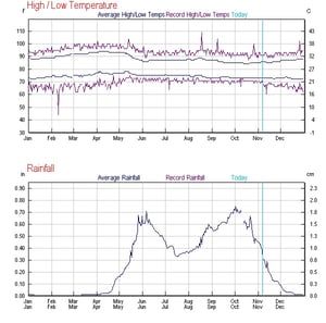
Here is a chart of average high and low temperatures and rainfall for Liberia that I found on Weather Underground. I'm curious about how the climate in Las Catalinas differs from that in Liberia. We have a weather station for Las Catalinas en route that will help us answer that question more definitively. I suspect we have a slightly narrower range of temperatures, somewhat less rainfall, and a different wind pattern due to onshore winds that are typical on many afternoons due to thermal current in response to heating of the air over land.
 Source: www.wunderground.com
- Monthly Climate Averages- this data is hard to come by (it does not show up on the big weather sites) and varies a bit according to source. Also it is all for Liberia, which is 19 miles inland from Las Catalinas and has a somewhat different climate.
- Detailed Forecasts and Current Conditions:
- Intellicast (Liberia) - shows current conditions including dewpoint, wind, and cloud conditions and a good summary of actual conditions for the previous 48 hours. It also has a ten day forecast, but you typically won't see much variation in there. For example the next ten days says "isolated thunderstorms" or "scattered thunderstorms" every day with a low between 69 and 72 and a high between 85 and 89.
- Wind Guru (Tamarindo) - for each 3 hours, has temperature, wind speed, wind direction, wave height, wave direction, wave period, percentage of cloud cover, and temperature.
- Magic Seaweed (Tamarindo) - a surf oriented site, has water and air temperature, along with swell height and direction, first light, sunrise, sunset, last light, wind speed and direction, and tides.
- Costa Rica National Weather Service Stations for Hacienda Pinilla and Liberia - these give current conditions and (interestingly) rainfall totals for the current and previous days. Pinilla is just south of Tamarindo, on the coast. It is interesting how different these can be for the two locations, which are 30 miles apart.


