 Colonia del Sacramento
Colonia del Sacramento
Portuguese: Colónia do Sacramento | |
|---|---|
Capital city | |
 | |
 Colonia del Sacramento | |
| Coordinates: | |
| Country | |
| Department | |
| Founded | 1680 |
| Founded by | Manuel Lobo |
| Elevation | 27 m (89 ft) |
| Population (2011 Census) | |
| • Total | 26,231 |
| Time zone | UTC -3 |
| Postal code | 70000 |
| Dial plan | +598 452 (+5 digits) |
| Climate | Cfa |
| Website | https://www.colonia.gub.uy/ |
| Official name | Historic Quarter of the City of Colonia del Sacramento |
| Criteria | Cultural: iv |
| Reference | 747 |
| Inscription | 1995 (19th session) |
| Area | 16 ha |
Colonia del Sacramento (Spanish: [koˈlonja ðel sakɾaˈmento] (![]() listen); Portuguese: Colónia do Sacramento) is a city in southwestern Uruguay, by the Río de la Plata, facing Buenos Aires, Argentina. It is one of the oldest towns in Uruguay and capital of the Colonia Department. It has a population of around 27,000.
listen); Portuguese: Colónia do Sacramento) is a city in southwestern Uruguay, by the Río de la Plata, facing Buenos Aires, Argentina. It is one of the oldest towns in Uruguay and capital of the Colonia Department. It has a population of around 27,000.
It is renowned for its historic quarter, a UNESCO World Heritage Site.[1] Modern Colonia del Sacramento produces textiles and has a free trade zone, in addition to a polytechnic centre and various government buildings.
Contents
[hide]History[edit]
.jpg)
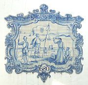
Following the restoration of the Portuguese crown, King Peter II sought the resolution of the southern border of Brazil. Manuel Lobo with 5 ships containing about 400 soldiers, craftsmen, carpenters and stonecutters, and 18 guns, reached San Gabriel Island [es; pt] on 20 January 1680. On 28 January, they commenced establishing a post.[2]
José de Garro sent spies from Santo Domingo de Soriano on 22 February 1680, after receiving a negative response on 10 February to his ultimatum to leave the site. Garro sent a force of 3,400 men under the command of Antonio de Vera Mujica, capturing the besieged town on the night of 6-7 August 1680. Lobo was taken as a prisoner to Buenos Aires, where he died on 7 January 1683. A treaty between Spain and Portugal signed in 1681 returned Colonia to Portugal.[2]:105–106,109
Field Marshal Duarte Teixeira Chaves arrived off the San Gabriel islands on 25 January 1683, and commenced to rebuild the settlement. Field Marshal Cristóvão Dornelas Abreu was its governor until 1690, when Dom Francisco Naper de Lencastre took over. Smuggling, and cattle hunting from the Banda Oriental, were the main components of the colony's economy. Lencastre ordered the building of houses of stone and mud with tile roofs, the enlargement of the city walls, and the addition of a fortified tower. The colonists grew wheat, hemp flax, and grape vines, exported cattle hides to Rio De Janeiro, while importing wood and foodstuffs. Sebastião da Veiga Cabral took over as governor in 1699.[2]:113–115,121–127,131
As a consequence of the War of the Spanish Succession, the governor of Buenos Aires, Valdes Incian, initiated the Siege of Colonia del Sacramento. The forces of the Spanish governor were commanded by Baltazar García Ros from 18 October 1704 until 14 March 1705, when the colonists were evacuated by Portuguese ships. Only the churches and bridge remained undestroyed.[2]:135–136,142
The colony was given back to Portugal in the Treaty of Utrecht. Manuel Gomes Barbosa took possession on 10 February 1718 with 1,040 colonists. More colonists arrived in 1721. Antonio Pedro de Vasconcellos took over as governor on 14 March 1722 and transformed it into the richest and best defended city in the Rio de la Plata region. This included the coastal bastions of São Pedro de Alcântara, São Miguel, Santo António, São João, Carmo, and Santa Rita.[2]:147–160,166,169
Another attack during the Spanish-Portuguese War, 1735-1737, failed. Don Luis Garcia de Bivar took over as governor in 1749, but died on 5 March 1760. During that time, the Treaty of Madrid (13 January 1750) was never complied with and finally considered null and void. Brigadier Vicente da Silva da Fonseca then took over as governor. Fonseca was forced to surrender the colony to Pedro Antonio de Cevallos on 11 October 1762. Spain returned the colony in the 1762 Treaty of Fontainebleau, and Dom José Pedro de Figueiredo Sarmento took over as governor on 27 December 1763. He was replaced by Francisco José da Rocha on 15 March 1777.[2]:170–175,177–178,187,195,202–203
With the Treaty of San Ildefonso in 1777, the colony became a Spanish possession once more.[2]:206–207
It then transferred to Portuguese control again, being later incorporated into Brazil after 1816, when the entire Banda Oriental (Uruguay) was seized by the government of the United Kingdom of Portugal, Brazil and the Algarves and renamed the Cisplatina province.
On 10 January 1809, before the independence of Uruguay, it was designated as a "Villa" ("town" in 19th century Portuguese) and has since been elevated to the status of "Ciudad" ("city" in Spanish).
Since independence, Colonia del Sacramento has expanded to the north and east, but the original Bairro Histórico (historic quarter in Portuguese or Barrio Histórico, current Spanish spelling) retains its irregular, terrain-fitting street plan built by the Portuguese, contrasting with the wider, orthogonal calles in the newer Spanish area.
Timeline of rule[edit]
The rule from 1680 to present (with flag of the period) is:
| From | To | Rule | Reason for Handover |
|---|---|---|---|
| 1680 | 1680 | conquered by José de Garro | |
| 1680 | 1681 | treaty between Spain and Portugal | |
| 1681 | 1705 | conquered in the War of Spanish Succession | |
| 1705 | 1713 | Treaty of Utrecht | |
| 1714 | 1762 | First Cevallos expedition | |
| 1762 | 1763 | Treaty of Paris (1763) | |
| 1763 | 1777 | Second Cevallos expedition | |
| 1777 | 1811 | Revolt led by José Gervasio Artigas | |
| 1811 | 1817 | Portuguese conquest | |
| 1817 | 1822 | Brazilian Declaration of Independence | |
| 1822 | 1828 | Cisplatine War | |
| 1828 | present |
Population[edit]
In 2011 Colonia del Sacramento had a population of 26,231.[3]
| Year | Population |
|---|---|
| 1908 | 8,021 |
| 1963 | 12,846 |
| 1975 | 17,046 |
| 1985 | 19,102 |
| 1996 | 22,200 |
| 2004 | 21,714 |
| 2011 | 26,231 |
Source: Instituto Nacional de Estadística de Uruguay[4]
Climate[edit]
Colonia del Sacramento has a mild humid subtropical climate, described by the Köppen climate classification as Cfa. Summers are warm and winters are cool, with relatively frequent frosts and fog. The precipitation is evenly distributed throughout the year, with an average of 1,039 mm (40.91 in), and the annual average temperature is 17 °C (63 °F).
| [hide]Climate data for Colonia del Sacramento , Uruguay (1980–2009) | |||||||||||||
|---|---|---|---|---|---|---|---|---|---|---|---|---|---|
| Month | Jan | Feb | Mar | Apr | May | Jun | Jul | Aug | Sep | Oct | Nov | Dec | Year |
| Record high °C (°F) | 39.6 (103.3) |
35.8 (96.4) |
34.9 (94.8) |
31.6 (88.9) |
30.9 (87.6) |
25.8 (78.4) |
30.6 (87.1) |
28.8 (83.8) |
30.6 (87.1) |
32.8 (91.0) |
36.4 (97.5) |
38.0 (100.4) |
39.6 (103.3) |
| Average high °C (°F) | 28.6 (83.5) |
27.1 (80.8) |
25.7 (78.3) |
22.0 (71.6) |
18.4 (65.1) |
14.9 (58.8) |
14.4 (57.9) |
16.6 (61.9) |
18.2 (64.8) |
21.4 (70.5) |
24.1 (75.4) |
27.0 (80.6) |
21.5 (70.7) |
| Daily mean °C (°F) | 23.8 (74.8) |
22.9 (73.2) |
21.5 (70.7) |
18.2 (64.8) |
14.9 (58.8) |
11.8 (53.2) |
11.1 (52.0) |
12.7 (54.9) |
14.1 (57.4) |
17.1 (62.8) |
19.6 (67.3) |
22.2 (72.0) |
17.5 (63.5) |
| Average low °C (°F) | 19.0 (66.2) |
18.6 (65.5) |
17.4 (63.3) |
14.3 (57.7) |
11.4 (52.5) |
8.7 (47.7) |
7.8 (46.0) |
8.9 (48.0) |
10.1 (50.2) |
12.9 (55.2) |
15.1 (59.2) |
17.4 (63.3) |
13.5 (56.3) |
| Record low °C (°F) | 10.1 (50.2) |
10.3 (50.5) |
8.1 (46.6) |
5.1 (41.2) |
0.2 (32.4) |
0.0 (32.0) |
−0.7 (30.7) |
0.4 (32.7) |
1.5 (34.7) |
4.7 (40.5) |
4.1 (39.4) |
8.8 (47.8) |
−0.7 (30.7) |
| Average precipitation mm (inches) | 101.3 (3.99) |
102.2 (4.02) |
134.0 (5.28) |
110.6 (4.35) |
89.5 (3.52) |
67.9 (2.67) |
65.3 (2.57) |
76.7 (3.02) |
72.8 (2.87) |
111.6 (4.39) |
112.6 (4.43) |
100.8 (3.97) |
1,145.4 (45.09) |
| Average precipitation days (≥ 1.0 mm) | 6 | 6 | 6 | 6 | 5 | 5 | 5 | 5 | 6 | 7 | 7 | 6 | 70 |
| Average relative humidity (%) | 66 | 70 | 73 | 74 | 75 | 77 | 76 | 73 | 71 | 71 | 68 | 66 | 72 |
| Mean monthly sunshine hours | 288.3 | 237.3 | 235.6 | 180.0 | 167.4 | 132.0 | 151.9 | 179.8 | 198.0 | 223.2 | 240.0 | 272.8 | 2,506.3 |
| Mean daily sunshine hours | 9.3 | 8.4 | 7.6 | 6.0 | 5.4 | 4.4 | 4.9 | 5.8 | 6.6 | 7.2 | 8.0 | 8.8 | 6.8 |
| Source 1: Instituto Nacional de Investigación Agropecuaria[5] | |||||||||||||
| Source 2: Dirección Nacional de Meteorología[6] | |||||||||||||
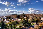
Urban fabric[edit]
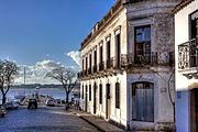
The city was developed on a peninsula that protrudes into the Río de la Plata. The 16 hectare "Barrio Histórico", or Portuguese Old City, was enclosed by a fortification wall across the peninsula in the site of present-day Calle Ituzaingó. Most of the fortification wall was removed in 1777 and the remaining parts in 1859. The Portuguese part of the city has an irregular street network.
Outside the wall, the historical part of the city was planned in Spanish colonial style and in the characteristic checkerboard layout.
Points of interest[edit]
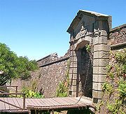
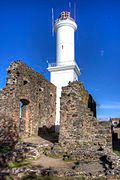
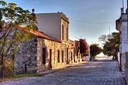
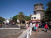
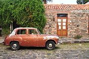
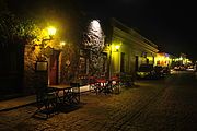
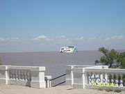
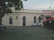
The Barrio Histórico (historic quarter) section of Colonia del Sacramento is designated a World Heritage Site by UNESCO. It is a popular tourist attraction for visitors from Buenos Aires, and there is frequent ferry service across the Río de la Plata between the two cities, with fast ferries completing the journey in just 50 minutes. The historical section of Colonia, which has some cobblestone streets built by the Portuguese in the 17th century, is within walking distance of the ferry terminal. Among the notable tourist attractions around the tree-lined Plaza Mayor (main square) are:
- Portón de Campo – the City Gate and wooden drawbridge
- Lighthouse and convent ruins of the 17th-century Convent of San Francisco
- Basílica del Santísimo Sacramento – the Basilica of the Holy Sacrament, built of stone by the Portuguese in 1808
- Portuguese Museum – constructed in the 18th century, it exhibits Portuguese furnishings, jewelry, uniforms and old maps of Portuguese naval expeditions
- Casa de Nacarello – an 18th-century Portuguese house
- Municipal Museum – rebuilt by the Spanish in 1835 as the Casa del Almirante Brown, it exhibits artifacts and documents of the city's different periods and cultures
- Viceroy's House – the Casa del Virrey, reconstructed from the original ruins
- Plaza de toros Real de San Carlos, a Bullring included in an old tourist complex now abandoned.
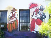
Gallery[edit]
- Views of the Barrio Histórico


Transportation[edit]
Colonia del Sacramento is served by three ferry boat lines from Buenos Aires, Argentina: "Buquebus", "Seacat Colonia" and "Colonia Express".
Two principal highways end in Colonia: Route 1 connects Colonia to Montevideo and points east; Route 21 connects to points north, including the Aarón de Anchorena National Park, 30 kilometres (19 mi) distant, and Fray Bentos. There is also a local airport for small planes. There is a project in process to lengthen the runway and begin commercial flights to Buenos Aires (this was done in the past) and other cities within Uruguay.
The city is served by Laguna de los Patos International Airport located 6 kilometres (4 mi) from Colonia along Route 1.
Consular representation[edit]
Argentina and Portugal both maintain a consulate in Colonia del Sacramento.
Twin towns – sister cities[edit]
 Guimarães, Portugal[7]
 Morón, Argentina[8]
 Olinda, Brazil[9]
- Pelotas, Brazil[10]
- Quilmes, Argentina[11]
See also[edit]
Bibliography[edit]
- Assunção, Fernando O.; Cravotto, Antonio (1996). Colonia del Sacramento, patrimonio mundial. Montevideo: UNESCO. (with prologue by Federico Mayor Zaragoza and introduction by Marta Canessa de Sanguinetti) (in Spanish)
References[edit]
- ^ "21 World Heritage Sites you have probably never heard of". The Daily Telegraph. London.
- ^ a b c d e f g Mayor, Federico; de Sanguinetti, Marta Canessa; Assuncao, Fernando; Cravotto, Antonio (1996). Colonia del Sacramento. UNESCO. pp. 88, 93, 98–103. ISBN 9230032956.
- ^ "Censos 2011 Cuadros Colonia". INE. 2012. Retrieved 25 August 2012.
- ^ "Statistics of urban localities (1963–2004)" (PDF). INE. 2012. Archived from the original (PDF) on 2009-11-13. Retrieved 3 September 2012.
- ^ Castaño, José; Giménez, Agustín; Ceroni, Mauricio; Furest, José; Aunchayna, Rossina. "Caracterización Agroclimática del Uruguay 1980–2009" (PDF) (in Spanish). Instituto Nacional de Investigación Agropecuaria. Archived from the original (PDF) on 12 December 2018. Retrieved 15 December 2018.
- ^ "Estadísticas climatológicas" (in Spanish). Dirección Nacional de Meteorología. Archived from the original on 30 November 2014. Retrieved 10 October 2012.
- ^ https://correiodominho.pt/noticias/guimaraes-e-colonia-de-sacramento-duas-cidades-geminadas-ha-varios-anos/109303
- ^ [dead link], Municipalidad de Morón, 4 July 2007.
- ^ "Olinda e Colônia de Sacramento são agora oficialmente cidades irmãs" (in Portuguese). Archived from the original on 23 April 2016. Retrieved 18 April 2014.
- ^ (in Portuguese) Cidades-irmãs de Pelotas terão espaço na Fenadoce Archived 2011-07-23 at the Wayback Machine, Prefeitura Municipal de Pelotas - accessed on June 4, 2007.
- ^ [dead link], Gobierno Departamental de Colonia, 22 November 2014.
External links[edit]
| Wikimedia Commons has media related to Colonia del Sacramento. |
| Wikivoyage has a travel guide for Colonia. |
- Article on Colonia del Sacramento, Official Portal of the Uruguayan Government Archived 2011-11-19 at the Wayback Machine
- 360° Virtual Tours of Colonia del Sacramento - Uruguay360.com.uy
- Tourist information about Colonia del Sacramento
- Tourist guide about Colonia del Sacramento – photos, hosting and attractions of Colonia del Sacramento attractions
- Colonia del Sacramento Website
- INE map of Colonia del Sacramento
- Colonia del Sacramento
- Populated places in the Colonia Department
- Port cities and towns in Uruguay
- Río de la Plata
- Colonial Uruguay
- Former Portuguese colonies
- Portuguese colonization of the Americas
- Populated places established in 1680
- 1680 establishments in Uruguay
- 1680 establishments in the Portuguese Empire
- Portugal–Spain relations
- Tourism in Uruguay
- World Heritage Sites in Uruguay
- 1687 establishments in Portugal